Finding the Way: Examining Flood Evacuation Route Choices in Kampong Settlements in Indonesia
2022/11/08
- Research
Scientists develop a low-cost method to make paper sheets fold themselves into honeycomb structures with superb structural and mechanical properties
Honeycomb structures are widely used in materials engineering owing to their attractive structural and mechanical properties, such as high porosity and low weight. In a recent study, Japanese scientists developed a method to produce self-folding origami honeycomb structures using nothing but paper, a cutter, and an inkjet printer. This low-cost technology is particularly promising for tailor-made protective packaging for fragile goods, including electronic components or vegetables, as well as protective gear, such as helmets.
Title:Juxtaposition between dwellers' evacuation route choice with the space syntax Normalized Angular Choice Radii.
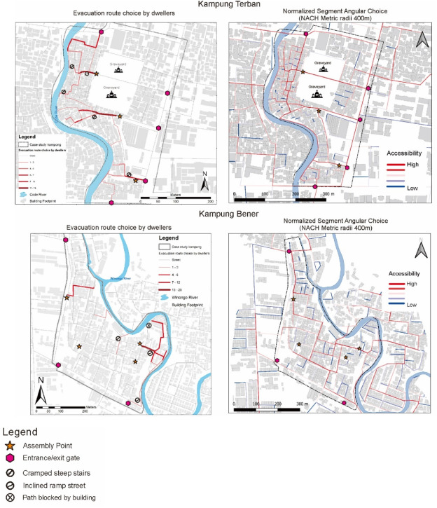
Caption:The figure shows the aggregate number of dwellers’ evacuation route choice in Kampong Terban and Bener (left picture) and the Space syntax results of Normalized Angular Choice at 400 m radii.The thick lines represent the aggregate number of evacuees traveling on a certain path segment. They indicate that a majority of riverbank kampong dwellers evacuate through the shortest and straightest route with the least angular deviation.
Credit:Hitoshi Nakamura from SIT, Japan
Usage restrictions: Do not reuse without permission
License:CC BY-NC-ND 4.0
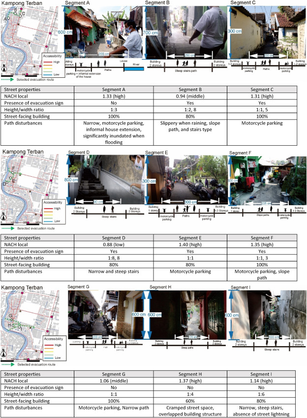
Title:In kampung Terban case studies, path network configuration is related to evacuation route decision making. Colored dashed lines represent the dweller's evacuation path route choices.
Caption:This is an analysis of path risk elements (external factors) from the perspective of evacuees through the walking evacuation simulation with video. The path risk elements of evacuation route constitute the built-form element such as street network configuration, presence of evacuation sign, spatial enclosure, street-facing building, and path use and disturbances. In summary, this figure depicts the complexity of evacuation route choice which can be effectively analyzed using a mixed-method approach to demonstrate the influence of the interplay of internal and external factors on evacuation behavior in urban riverbank kampongs.
Credit:Hitoshi Nakamura from SIT, Japan
Usage restrictions: Do not reuse without permission
License:CC BY-NC-ND 4.0
Recently, Mr. Irsyad Adhi Waskita Hutama (a Doctoral Program student) and Professor Hitoshi Nakamura of Shibaura Institute of Technology, Japan, analyzed the dynamic interaction between human characteristics, path risk elements, and path network configuration in constructing flood evacuation route choices. The study was conducted in Terban and Bener, which are two urban riverbank kampongs (villages) in Yogyakarta, Indonesia. Their findings were made available online on 1st September 2022 and published in Volume 81 of the International Journal of Disaster Risk Reduction on 15th October 2022.
Prof. Nakamura reveals his motivation behind the research: “Riverbank kampongs in Indonesian cities have grown spontaneously. Their residents typically include low-income and marginalized people who lack disaster prevention infrastructure. I am interested in how such communities can undertake disaster risk management and mitigate future disasters. A study on evacuation measures in riverbank kampongs will indicate reliable life-saving actions in response to flood, earthquake, and other disasters.”
The researchers applied a mixed-method approach. First, they collected extensive data regarding path risk factors through walking evacuation simulations recorded on video. Next, walking interviews were conducted to gain exploratory information on individual capacity and decision-making. Finally, the researchers performed computational path network analysis using the Space syntax model. The results of these analyses were combined to paint the overall picture.
Their findings suggest that riverbank kampong dwellers select evacuation routes based on their individual capacity and the safety performance of path design. Many of them rely on safety perception instead of following spatial logic. Consequently, their evacuation route decisions might be compromised. Moreover, the walking interview revealed that men had higher spatial legibility and path safety perception than women in both case studies.
Further, the researchers juxtaposed the Space syntax results with the walking evacuation simulation. The individual evacuation route selection was found to be highly related to the “normalized angular choice at local radii.” This implies that a majority of residents prefer to walk on the straightest route—with the least angular deviation—to reach the assembly points. Furthermore, in agreement with the personal interviews, the residents have different capabilities to walk on the straightest evacuation path. In particular, physical capacity, gender, and age affected people’s decisions in negotiating path risk elements and accommodating the safest travel.
Prof. Nakamura points out the long-term implications of the study. “Our study attempts to bridge the research tradition on disaster studies that focus on the morphological approach on one hand, and a human-centered approach on the other. Its findings indicate a policy insight that includes routine disaster prevention actions consistent with the socio-spatial profile of the kampong's marginalized. The enhancement includes not only structural measures such as human-sensitive urban design, readability of evacuation routes through signage, and the provision of evacuation infrastructure but also community preparedness. These measures should be included in kampong upgrading and slum alleviation policies aimed at achieving the SDGs.”
Overall, the study highlights the use of mixed-method approaches and emphasizes the need to consider the human-centered perspective in effective flood emergency evacuation planning for informal riverbank settlements.
Reference
| Title of original paper: | Flood disaster evacuation route choice in Indonesian urban riverbank kampong: Exploring the role of individual characteristics, path risk elements, and path network configuration |
| Journal | International Journal of Disaster Risk Reduction |
| DOI: | 10.1016/j.ijdrr.2022.103275 |
Contact
Planning and Public Relations Section
3-7-5 Toyosu, Koto-ku, Tokyo 135-8548, Japan (2F the Centennial Main Building, Toyosu Campus)
TEL:+81-(0)3-5859-7070 / FAX:+81-(0)35859-7071
E-mail:koho@ow.shibaura-it.ac.jp