Global-Local Path Choice Model: A New Method to Understand the Walkability of Cities
- Research
The novel route-choice model elucidates the influence of different attributes of a path on the local and global path choices of pedestrians.
Traditional route choice models for modelling walkability fail to capture the extent to which different attributes influence the global and local path choices of travelers. To address this gap, a researcher from Shibaura Institute of Technology has developed a novel global-local path choice model. This innovative model can introduce a new way of analyzing walkability and elucidates the influence of visual attributes of a path on the local adaptations of path choices of pedestrians.
Title: Global and Local Path Preferences Captured by the Global-Local Path Choice Model
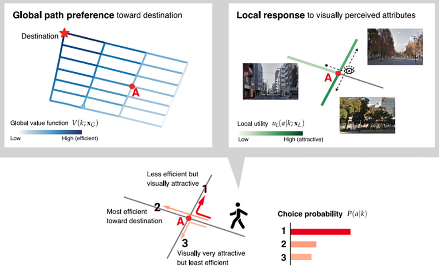
Caption: The global-local path choice model explains the extent to which different attributes influence the global and local path choices of pedestrians. In this example, the pedestrians are more likely to choose street 1 which is more visually attractive than efficient
Credit: Professor Yuki Oyama from Shibaura Institute of Technology
License: CC-BY 4.0
Usage restrictions: You are free to share and adapt the material. Attribution is required, with a link to the license, and you must indicate if changes are made to the work.
In many cities worldwide, the notion of walking as sustainable urban mobility is becoming increasingly popular. Improving the walkability of cities has many benefits, including improved health, reduced traffic, and consequently lower air pollution. To improve walkability, it is important to conduct a thorough analysis of what factors make cities more walkable.
One essential aspect in analyzing walkability is understanding traveler behavior. Before and during their journey, various factors can influence their path choices. For example, travelers can consider the most efficient route before starting but could encounter unexpected events necessitating route changes. Factors like surface conditions, traffic lights or a more scenic view can also influence their decisions. As such, the path choice of travelers can be categorized into two routing mechanisms - global path preferences and local responses to the perceived attributes of the path. While global preferences like the total distance can play a role, pedestrians often prioritize locally perceived attributes. Thus, it is necessary to understand to what extent and which attributes influence the global and local preferences of travelers and related design policies.
To address this, Associate Professor Yuki Oyama from the Department of Civil Engineering at Shibaura Institute of Technology, Japan, developed a novel network path choice model, called the global-local path choice model. “Traditional route choice models typically assume that travelers mainly have global preferences such as using the shortest path. However, in reality, travelers locally perceive and respond to different attributes of a path and capturing this behavior has been challenging. The present model successfully analyses this behavior,” explains Dr. Oyama. The details of the model were outlined in a study published in the journal Transportation Research Part A on February 13, 2024.
Central to this innovative model is a reward decomposition approach integrated into a link-based (Markovian) path choice model, which considers path choice as sequential link choices towards the destination in a Markovian way. In this approach, the Markovian reward function is broken down into a global utility, which is a function of attributes that can be globally perceived from anywhere, and a local utility, a function of attributes that can be only locally perceived from the current state. This enables empirical analyses of the influence of different attributes on the local and global path choices of travelers.
Dr. Oyama applied this model to study a real pedestrian network using GPS data collected from pedestrian movements. In this analysis, the green view index (GVI), which represents the greenery around streets, extracted from Google Street View images, was used as a locally perceived attribute. The idea was to study how visual street quality influences the decisions of pedestrians. The results revealed that pedestrians locally perceived and reacted to GVI values, rather than having pre-trip global perceptions of the values. Moreover, results also revealed the importance of the location of interventions like increasing greenery and showed that interventions should be placed on streets that are directly connected to the most walked-on streets.
Highlighting the potential applications of the study, Dr. Oyama remarks, “This method can be used as a decision-making tool for the design and control of a transportation network as well as visual information provision for route guidance. Moreover, beyond travelers in transportation networks, this model can contribute to elucidating the routing behavior of other agents like animals.”
Overall, this study provides a new way for analyzing walkability from the viewpoint of pedestrians’ local responses to the environment, paving the way for more walkable and environment-friendly cities!
Reference
| Title of original paper: |
Global path preference and local response: A reward decomposition approach for network path choice analysis in the presence of visually perceived attributes
|
| Journal: | |
| Article link: | 10.1016/j.tra.2024.103998 |
Authors
About Associate Professor Yuki Oyama from SIT, Japan
Yuki Oyama is currently an Associate Professor at the Department of Civil Engineering at Shibaura Institute of Technology. He obtained his bachelor’s and master’s in engineering from the University of Tokyo in 2012 and 2014, respectively, followed by a Ph.D. in 2017. At SIT he currently leads the Activity Landscape Design (ActScape) Lab. In 2017, he received the Kometani-Sasaki Award for his PhD thesis from Institute of Systems Science Research, Japan. His main research interest is developing new methodologies for modelling and analyzing agents’ behavior in networks, particularly, urban transportation networks, such as congested transport networks, pedestrian activity networks, and sustainable transport networks.
Funding Information
This work was financially supported by JSPS, Japan KAKENHI Grant numbers 20K14899 and 23H01586. The data for the case study was collected through a Probe Person survey, a complementary survey of the Sixth Tokyo Metropolitan Region Person Trip Survey.